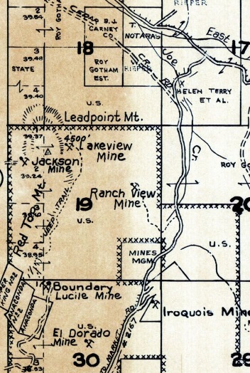
Leadpoint Mountain Lookout Site on (Red Top Mountain)
WillhiteWeb.com
In 1938, an L-4 was built.
In the 1950s, the lookout was removed.
The exact location is unknown to me but Metsker maps shows Leadpoint Mountain at the north end of Red Top Mountain. The Kresek inventory places the location on the summit of Red Top Mountain, at the north end in section 19. USGS maps do not label the highest peak of Red Top Mountain as Leadpoint Mountain but Metsker has the name nearby. I think Metsker would have the label closer to the summit but the names of the various mines pushed the label a bit off. It is also possible the lookout was not on the highest point but just to the north on some prominent points. Hopefully footings are on the summit to settle the matter.
Lookout Elevation: 4,620 feet
Hiking Distance: Have not done yet
Elevation Gain: Have not done yet
County: Stevens

1963 Metsker
