
Located in the Snoqualmie Tree Farm, Fuller Mountain was named for Walter Fuller who came as a pioneer to Snoqualmie in the early 1880s, he homesteaded near Fuller Mountain. What Fuller Mountain lacks in elevation, it makes up in unique prominence as the blob just rises from the flat topography surrounding it. Once this was a popular hike but land ownership changed and new ownership started charging a fee to hike and recreate here. With a $10 day pass, visitors were welcome, assuming you can get a permit for the day you want.
WillhiteWeb.com
Summit Elevation: 1,880 feet
Hiking Distance: 5 miles round trip
Elevation Gain: 840 feet
Prominence: 820 feet
Access: Good Gravel Roads, Access Permit Needed
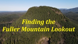
Fuller Mountain Lookout Site
There is a trail up to the top. It is unclear when the trail was built but quite a bit of work went into constructing it. It has become eroded in places where the hillside is slowly sliding down but in the stable areas, the work and route design of the trail is obvious, and not a social trail. The trail today is occasionally maintained by random volunteers and has been for decades. I have not tracked down when the trail was built but I like to think it originates back to the 20s.
The Trail
In December of 2023, Dave Battey, a historian for the City of Snoqualmie shared 2 photos of an old fire lookout on Fuller Mountain from the 1920s. His dad, George Franklin Battey staffed it for a time period. The annotations for the lookout photos are in his dads distinct handwriting, so that is fairly solid evidence. He is in one photo and his lookout buddy Harold Lundberg is in the other photo. The photos are two similar but different structures. George Battey worked for the Snoqualmie Falls Lumber Company in 1923 as a temporary seasonal worker to supplement income from a family farm and later became a permanent and year-round employee, living in logging camps A & B near Snoqualmie.
Lookout History
Going back up this time to investigate was nice because there is a nice rocky perch near the summit that I had not visited the first time. Unfortunately, the two lookout images reveal nothing about the location, other than the perches were at the edge of some kind of viewpoint. We did not find any evidence. I had brought a metal detector and pick axe but we just did not see anything to warrant really digging around. There were many places the structures could have been perched and it makes sense to have multiple viewing areas given the flatness of the summit. We will just have to wait for some more evidence to come to light.
2023 Visit


Around the same time period, the nearby Snoqualmie Falls observation platform was also a similar style and could be the inspiration of the structures on Fuller Mountain built by the Snoqualmie Falls Lumber Company.
Walter Fuller images
Taken March 1938 by Al Church from the summit area (Boyle and Bridges Lakes)
Using Google Earth to match same image as the 1938 image above.
Two images taken between 1944 and 1955 by Harold Keller, looking NE from the summit area.
George Franklin Battey in the 1920s at the Snoqualmie Falls Lumber Company fire lookout atop Fuller Mountain (provided by his son Dave)
Harold Lundberg on Fuller Mountain with photo by George Battey
Note that these are 2 different structures, likely 2 viewpoints on the mountain.
I did find photographs on the website of the Snoqualmie Valley Museum that were taken from Fuller Mountain in the 1930s and 1940s. There was a definite view at that time. Using Google earth, I confirmed the shots were taken from near the summit of Fuller Mountain. I also flew my drone to confirm.
Other Photographs
In 1937, a USGS monument was placed at the summit but no mention of any lookout. They climbed via a route on the east side near the old landslide but given the flatness of the summit benchmark area, I do not believe the lookout would have been there since you would not have been able to see much of the terrain below.
USGS Visit
In 1913, the Weyerhaeuser Timber Co Timber Estimate and Land Examination said, the timber on Fuller Mountain will be hard to handle as it is so steep and broken and will probably not pay to handle at present. But there is no great amount on the mountain. The surface is covered with a thick growth of underbrush mostly of vine maple, young hemlock and fir, huckleberry, elder, and devils club and salal.
Even Earlier Visits
A permit is required to enter the Snoqualmie Tree Farm and officials have parked at the gate before checking permits. But, the trail is right across the road from the gate and once on the trail, you are likely safe from security. A day permit is $10 for now. Parking is at the 10 Gate just off the North Fork Snoqualmie River Road.
Access


Two images taken in 2023 just above the trees from eastern viewpoint.

Maybe located here


1930s USGS survey parties reported having to hike the Fuller Mountain Trail from McLeod Lake. Although the trail was called the Fuller Mountain Trail, the trail just passed the mountain on the East side as it traveled north. This 1923 map shows the road ending near McLeod Lake.


Lidar map

On south rim looking SW over Klaus Lake below. Trees block vew now.

Fuller Mountain Trail
Fuller Mountain Trail
Lions Mane as viewed on way up the mountain, on NW ridge off the trail a bit.

Rock Bald on eastern summit was the destination of the built trail