Duck Island – Original Homestead
WillhiteWeb.com
(A Bit of Background)
We learn from an article published by Woodson Co. Historical Society, January 1978 where the first log cabin was located when our Willhite line moved from Missouri to Kansas. It is located in volume II, no. 41 of "In The Beginning". A few paragraphs say:
"What is now known as Duck Island was a high timbered bluff with the Verdigris River running along the north side of the bluff and going on across the valley where the bluff ended. On top of this bluff was a log cabin, home of the Willhite family."
"Rufus and Elizabeth Willhite and sons had come into the Verdigris Valley in 1858. In the latter part of 1859 or 1860, Rufus at the age of 63 died of apoplexy. The claim to the Willhite family was the southwest quarter of Section 24, township 26, Range 13. To the east side of the bluff and on the south side of the Verdigris River was a tract of land of 15 acres more or less. On April 27, 1861, Elizabeth Willhite sold this tract of land to John N. Walkup for $65.69."
It looked like Elizabeth sold the original cabin location on the bluff but much of the remaining land was retained. It seemed possible there would be some evidence of a homestead from when Julius or even John Walkup was there. I wanted to find this cabin location. Since the spot was now a protected island in a reservoir and had little development even before the surrounding area was flooded in the 50's, I was hopeful something could be found.
(The Visit to Duck Island)
I owned a one man rubber raft that was barely lake worthy. Looking at the winds the lake was capable of producing, I was getting a little concerned about paddling out to the island or at least getting back in the mid morning hours.
While we were visiting some graveyards around the reservoir, Carol took us to a few locations where I might be able to launch my raft the next morning. While doing this, Richard was thinking hard about how he was going to get on the island as well. As we drove into the Toronto Point Campground to view the distance from there to the island, Richard revealed his plan. He wanted to drive around the campground looking for someone with a motor boat. He would offer him cash for a ride out to Duck Island. Unfortunately, prospects didn’t look good. There were few campers and only one had a boat. So we pulled up and started explaining our offer. He agreed to it and we set up a time the next morning. From the back seat, James asked what his name was. He responded with his name and Carol suddenly realized she was related to the guy. She grabbed his face and said "I know you!" It was hilarious. He kind of recognized her but weren’t confident in saying anything, probably because our request was so strange.
That evening, we realized we wanted to get 5 of us out there but the boat only carried 5 which includes a driver. So, we asked our boat guide to make two trips and we would increase the offer. He was ready for us in the morning and had no problems with the double trip for him. We all eagerly jumped into the boat, excited at this new twist in the agenda.
On the way over, we gathered any information we could from the driver, since he was local. We had been talking with several other people over the last few days about the reservoir level and just how high historically it has got on the island. Some would swear that a few times, the reservoir completely covered the island that only a few tree tops were above the water. Others disagreed, that a few parts always remain above the water line. Looking at USGS maps, one part of each end of the island should remain above the water line based on the height of the dam. This would be important because water and driftwood could completely destroy or cover any signs of a homestead on the island.
We arrived and split up to cover the most ground. We brought a few 2-way radios and exchanged cell phone numbers, although coverage was spotty. In places, the brush and grass was thick and anything found would be hard to see. But, some areas were open and a few looked promising. The most promising spot we found was on the western side of the island where an old barb wire fence was passing through the center of some old oak trees. The trees looked to be between 100 to 150 years old. The wire ran through several trees in a row, right through the center. Basically, the wire was attached to them when they were small oak trees, then they grew big engulfing the wire. Also near this, we found the ground had been disturbed and dug up in a few places. It looked like a barn or cellar could have been there as the dug up area was quite large. It was also located in an area that had exposed rocks for building and would have had a perfect view down to the Verdigris River.
Our time was up after a few hours but we were happy to have found some evidence of a homestead. We all enjoyed the experience as we reflected on the significance of the spot. This is where Julius & Elizabeth first settled in Kansas and the spot where Julius probably died as well. Shortly after Julius died, all the family was settling in the valley below, taking up farming. The cabin on the hill wasn't a good location to farm and Elizabeth sold it one year later.
As always, please contact me if you have any historical information about Duck Island, willhiteweb*yahoo.com


Loading in the boat
Arriving to Duck Island
Terrain on Duck Island
The open terrain on Duck Island
Looking close, you can see two barb wires going through the center of the tree
From Duck Island looking back to the campground. That is the boat bringing 2nd load.
The area on the western side of the island where some habitation was found
Rocks below the site, working our way down to the water to get picked up
Below the possible homestead site, you can see it was above the steep north facing bluff
It's hard to see in the picture but this entire area drops into a square bowl about 4 feet lower than the surrounding area. The trees growning inside were younger than many of the trees outside of the depression.


The two highpoints that shouldn't flood because of the dam level are here
We launched the boat from this campground
X
Location of possible homestead site we found
1991 aerial photo with low reservoir level
USGS map shows that water can cover island except for two points. Double dashed line shows course of the river before it was flooded. Arrows is where the legal description says the homestead was located.
This is a 2005 aerial shot showing much of the island covered in water except for the "high timbered bluff" area as described in "In The Beginning"


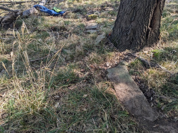
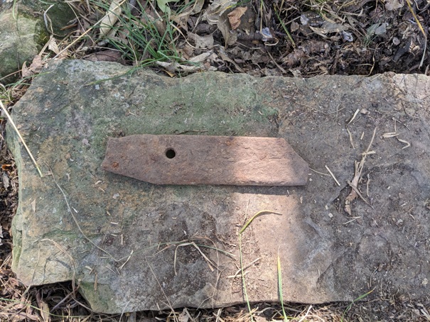
I have looked over the occupation site on the west end of the island. Sitting on the bedrock as it is, it was a simple matter to kick around through the leaves and see what objects were associated with that basement pit. There was not anything past the turn of the century. It appeared to be a plumbed and electrified dwelling that was in use until the 40s or 50s. However, about a hundred yards to the east, there is a nicely made, dry stone foundation peeking out of the ground amongst some trees. The stone foundation is pushed out of line by the growth of the oak. It takes a right turn at the end and dips underground. There is an iron bar cut from a repurposed wagon tire. Not much evidence here, but it has the feel of a settlement era site. The location is:
37.763584°N 95.944063°W (Michael Tracy visited and sent the two images above)


